An effective industrial subdivision must balance maximum land utilization (yield) with functional usability, ensuring each lot remains accessible, compliant, and marketable. Over-optimization can lead to irregular plots, poor circulation, or non-compliance, while under-optimization wastes valuable land. The key is a site-responsive layout that fits zoning codes, access norms, and utility needs.
Below are the core design principles that help achieve this balance:
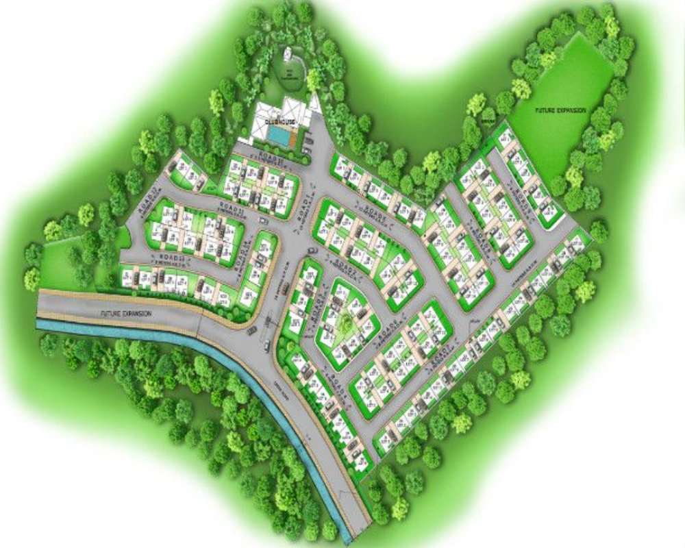
1. Use a Rectangular Grid or Loop Road Layout
- Benefits:
- Allows for uniform, rectangular plots with optimal frontage-to-depth ratios.
- Facilitates two-sided lot access and easier truck movement.
- Allows for uniform, rectangular plots with optimal frontage-to-depth ratios.
- Design Tip:
- Avoid T-junctions and dead-end roads that create unusable corner zones.
- A loop or spine-and-branch model reduces road space while maintaining access.
- Avoid T-junctions and dead-end roads that create unusable corner zones.
2. Apply a 25–35% Allocation for Non-Saleable Land
- Allocate space for:
- Internal roads: ~10–12%
- Green buffers/setbacks: ~5–8%
- Utility corridors & stormwater drains: ~5%
- Common infrastructure (CETP, substation, fire lanes): ~5–10%
- Internal roads: ~10–12%
- Aim for 65–75% net usable plot area after all deductions.
3. Optimize Plot Sizes and Standardize Modules
- Use modular plot dimensions like 0.5, 1, 2, or 5 acres.
- Ensure lots have:
- Minimum 15–30m frontage (as per zoning)
- Depth-to-frontage ratios of 2:1 to 3:1 to accommodate structures and parking
- Minimum 15–30m frontage (as per zoning)
- Group larger plots near arterial roads and smaller ones deeper inside for better market segmentation.
4. Preserve Access and Serviceability for Each Plot
- Every lot should have:
- Direct access to an internal road
- Utility availability (power, water, sewage) along the road edge
- Direct access to an internal road
- Avoid flag-shaped or “rear” lots that depend on narrow passages unless easements are planned.
5. Shape the Layout to Fit Site Constraints and Maximize Perimeter Use
- Align roads with natural contours to reduce cut-and-fill costs.
- Use irregular site edges (curves, tapers) for:
- Utility corridors
- Buffer zones
- Landscape or water recharge areas
- Utility corridors
- Reserve central and rectangular zones for high-value plots with optimal buildability.